
Owyhee County announced the start of the OI process in 2001. Local and national environmental groups soon jumped in bed with the County to sell out the wildlife habitat and biodiversity of the region. Its bedrock principles were that public lands ranching would be paramount, voices of opposition to grazing would be excluded, and future National Monument designation would be precluded. An agreement was developed elevating rancher and local control of public lands, predicated on “preserving livestock grazing as an economically viable use”. In a 2004 compilation, I wrote about Sagebrush Rebel/Wise Use/County Supremacy advocates and right-wing politicians backdooring local control of public lands into mainstream acceptance via collaborative groups, and other issues swirling around the OI.
In 2019, just across the state line, Oregon Senators Wyden and Merkley introduced Malheur County public lands legislation containing elements of the OI agreement and other ecologically malign provisions. This set me to rummaging through old files, where I exhumed a press release by the Wilderness Society’s Craig Gehrke, an ardent bill backer, on the OI’s one year anniversary. With the Malheur Bill’s emergence, it’s instructive to compare promises made about the OI, and the current situation on the ground in Idaho. The old press release touted that the bill: Designated 517,000 acres of wilderness and 316 miles of Wild and Scenic Rivers; Released 200,000 acres of Wilderness Study Areas (WSAs); Authorized a science center for “natural resource management issues”; Allowed grazing permit retirement in and by wilderness; Created a fund to purchase lands or interests in wilderness from land sales in the Boise BLM District; Directed coordination with the Shoshone-Paiute Tribe; and Required travel management plans for Owyhee County. Here’s a critique of where matters now stand.
The OI Ignored Nearly A Million Acres of Wilderness-Suitable Lands and Released 200,000 acres of BLM WSAs
A 1999 Citizens Wilderness Inventory proposal for BLM-managed lands across Idaho contained 1.3 million Owyhee County acres, including 700,000 acres of WSAs with interim protection. It was prepared by the Committee for Idaho’s High Desert and American Lands Alliance and was endorsed by Idaho Conservation League (ICL), TWS and the Sierra Club. Subsequent Sierra Club inventories bumped the potential wilderness land up to 1.6 million acres. The OI ultimately designated less than one-third of those potential acres as wilderness.
In the 2000 twilight of the Clinton administration, environmental groups sought an Owyhee National Monument designation. Interior Secretary Bruce Babbitt had shown a keen interest in expanding Craters of the Moon (largely lava). Clinton delivered. However, the biggest threatened landscape in Idaho was found in the high desert sage plateaus and juniper forests of the Owyhee. Environmental groups prepared a proposal for a 2.7 million acre Idaho Owyhee Monument (Schnitzpahn et al. 2000) with contiguous expanses of public land to conserve the biodiversity attributes of the region.
“The Owyhee-Bruneau canyonlands is not a mere chunk of land that can be sliced into parcels managed for specific uses, but a contiguous entity … that must be envisioned as an entire landscape”.
 The political power of the cattlemen squelched a Monument designation. I recall being in DC with Mike Medberry in a last-ditch lobbying effort, facing closed doors, when the Supreme Court Bush v. Gore decision came down. Bleak times.
The primary threats to the Owyhee region back in 2000 were (and still are): Livestock grazing causing irreversible annual grass invasion (cheatgrass, bulbous bluegrass and medusahead which have now dramatically expanded); Chronic cattle damage to native sagebrush, juniper and riparian habitats; Noxiously loud military overflights down to levels as low as 100-500 ft; and Fire impacts exacerbated by grazing-caused weeds, desertification and BLM’s rehab policies.
From its 2001 start onward, the OI was led by County “coordination” huckster Fred Kelly Grant. Legislation was introduced in 2006. Idaho’s long-time Republican Senate seat-warmer, Mike Crapo, was the adult supervisor. His natural resources aid, coyote thrill killer
Layne Bangerter, later a Trump EPA-gutting beachhead team member, became very involved. Participating environmental groups were TWS, ICL, The Nature Conservancy (TNC), Idaho Rivers United (IRU), and the Sierra Club. The OI process dragged on and on, with Grant and the ranchers in charge. In retrospect, it was likely prolonged on purpose. Aggressive litigation over cattle-caused habitat havoc in 68 Owyhee allotments, and across the region, was underway. The OI was a feel-good foil to counter grazing reform pressure. Periodic news reports were pumped out by the local grazing fanboy journalist, breathlessly in awe of collaboration. I recall trying to attend an OI meeting with a colleague. Grant, later to be a militia and Bundy sympathizer, forbid us from speaking. It seems that is what collaboration is all about – silencing those concerned with dealing away public lands. The meeting was held in the Stewards of the Range property rights group office, run by Wayne Hage’s daughter Margaret Byfield, and Grant. Stewards has now morphed into American Stewards of Liberty.
At the same time, pushback against Quid Pro Quo wilderness bills sacrificing public lands as part of a wilderness grand bargain with industry was occurring. This was a reaction to Nevada bills that disposed of public lands, the privatization of 10,000 acres in the Steens, and other controversial legislation. The initial OI agreement language in bill form was rejected by Democratic Congressional staffers. New Mexico Senator Jeff Bingaman was making efforts to clean up wilderness bills, so the most outrageous elements were toned down or dropped in the final language. But the damage had already been done. The ranchers and their environmental enablers today continue to push for the OI provisions as they saw them circa 2004.
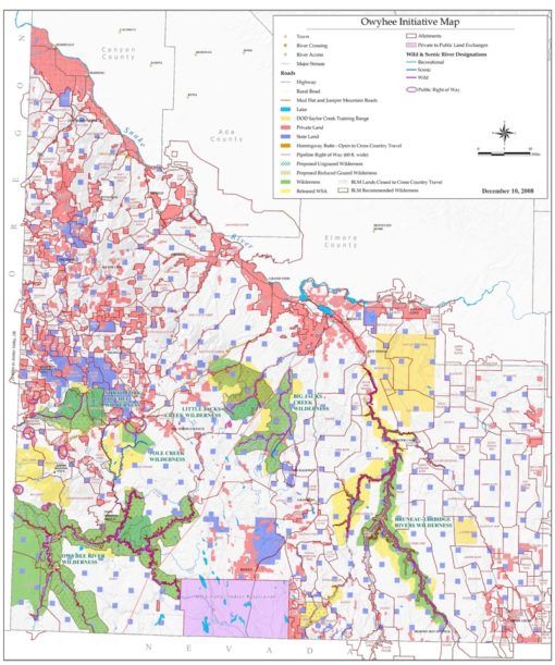
Green is the OI wilderness. Looking at this map now, it’s striking how little wilderness was designated.
Released WSAs and Lands with Wilderness Characteristics Now Under Threat
Blocks of WSAs in the rugged Juniper Mountain area, and individual WSAs, were released in the OI. Portions of WSAs that survived being cut entirely were “shaved”, a term the OI participants embraced. This further shrunk stringer WSAs running along river canyons.
The OI group’s website bragged about 200,000 acres of WSA release. The site highlighted that 200,000 acres of the Owyhee wilderness would be located within one mile of a road (due to the shaved WSAs, high road density, and many dead-end cherry-stem roads piercing the wilderness that were left open for cattlemen). Rancher desires drove the process. WSAs were released, not because they didn’t have wilderness merit, but because ranchers who grazed there didn’t want wilderness. Essential Sage-grouse habitat in the Bruneau country and elsewhere was released.
Nearly all wilderness-worthy lands outside WSAs were ignored for inclusion in the bill, except the 45 allotment west of the South Fork Owyhee River, bordering Malheur County. The 45 Ranch (likely the most remote ranch in the lower 48) consisted of a tiny 240-acre private land base property with a 65,000 acre grazing permit attached. There’s a backstory to pretty much every part of the OI. Here, TNC acquired the ranch, showcased it in grazing propaganda, then sold it to a wealthy buyer interested in the area’s remoteness, not in running cows. The new buyer supported wilderness designation. TNC had found it was too expensive to run a “for show” cow operation in the middle of nowhere, complete with a scofflaw rancher who bulldozed the river. They had come by the ranch in a round-about way after a defeated 1990s Air Force Andrus Split Bombing Range proposal in the YP Desert by the South Fork. A Bighorn Sheep advocate bought the ranch after its reclusive owner died, to be better positioned to oppose military expansion, and TNC then ended up with it.
Circa 2012, BLM conducted new inventories for Lands with Wilderness Characteristics (LWC). Some BLM staff were concerned about the WSA release and other OI elements. The new inventories found nearly all the released WSA lands retained wilderness characteristics, and that large areas of non-WSA lands did too. I’m not aware of BLM preparing a summary public document. The new LWC inventory seeped out in grazing NEPA analysis for the 68 Owyhee allotments and in deforestation projects targeting released WSAs on Juniper Mountain. There, right after BLM’s own new inventories found that forest cover was an important element of the wilderness values, BLM signed decisions to destroy the forest. Several minimally roaded large expanses of sagebrush habitat were rejected in the new BLM inventory. The BLM has a long history of rejecting lands without striking rock outcroppings or canyons. I asked a BLM staffer involved why those areas were left out. He replied “Sage-grouse will protect them”. Wrong.
Since the OI’s passage, juniper forests across released WSA and LWC areas have been under assault from BLM vegetation destruction projects. OI group cattle consultant Chad Gibson had openly stated that an intent of the OI collaboration was to make sure nobody goes back to Congress trying to add more wilderness, and to ensure against future Monument attempts. This agenda is being carried out on the ground by BLM today, without resistance from, and/or enabled by, the OI collaborators.
The green groups abandoned the released WSAs to juniper destruction projects like BLM’s ancient forest ecocide project that in 2019 napalmed trees in released WSAs on Juniper Mountain. Currently an immense > 600,000 acre Bruneau-Owyhee Sage-grouse Habitat (BOSH) juniper eradication project is aimed at wiping out nearly all trees within 4 miles of Sage-grouse leks, including in released WSA lands and LWC areas. The groups joined with the cattlemen in speaking out against grazing reform attempts in the 68 Owyhee allotments with crucial Redband Trout and Sage-grouse habitats, both inside and outside designated wilderness. Taking the side of the ranchers, they co-signed a letter trying to get BLM to back off cutting cow numbers. Only the Sierra Club, listed on the signature page as “out of town”, did not sign. Owyhee cattlemen continue to fiercely resist even the smallest grazing changes and are engaged in never-ending appeals processes.

Garat allotment grazing. This is one of the Owyhee 68 allotments where a wealthy ranching operation to this day resists grazing changes.
Mammoth New Fuelbreaks Threaten Wild Lands
The Tri-state Fuelbreaks BLM EIS proposal is a major new threat to wild lands ignored in the OI, as well as to hundreds of thousands of acres of Citizen Inventory units cast aside in the Oregon Malheur bill. The Fuelbreak proposal will fragment Sage-Grouse, Pygmy Rabbit and other rare species habitats, destroying sagebrush across the core of the largest block of Focal Habitat identified in the 2015 Sage-grouse plans. After BLM destroys the sage, it will be replaced with seedings of exotic crested wheatgrass or highly invasive forage kochia.
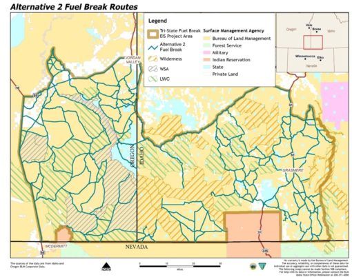
Proposed fuelbreaks (blue lines) will carve up habitat and promote flammable weed spread. Bulldozer blading will cement in place the permanent roading footprint of what currently are jeep trails. Fuelbreaks will extend 200 ft on both sides of roads.
“ a 73,920-acre fuel break network along approximately 1,539 miles of existing roads; 35,043 acres along 731 miles in Idaho, and 38,876 acres along 808 miles in Oregon. Roadbed vegetation removal, using either blading or manual methods, would occur across up to 412 miles of roads in Idaho and up to 537 miles of roads in Oregon, for a total of up to 950 miles of roads cleared.
Sage will be killed with “seedbed preparation techniques (i.e., disking, herbicide, prescribed fire, targeted grazing)”. Road edges would be bladed bared. Plant poisons of choice are: 2,4-D, aminopyralid, chlorsulfuron, clopyralid, dicamba, fluroxpyr, glyphosate (Round Up), imazapic, metsulfuron methyl, picloram (Tordon), rimsulfuron, triclopyr. Some of these toxics remain active in manure, so not only would there be application drift and drift in wind-blown soil, but also cow manure drift. EIS scoping meeting presentations showed images of a spray plane hosing the landscape.
Fuelbreaks won’t stop big climate-driven fires, with embers blown far in front. Upgraded roads increase human access and fire risk. The best defense wild country often has is a bad road. They will increase fire frequency – once the flashy fuel grasses spread outward under grazing, or catalytic converter fires set the road verge weeds ablaze.
Claims of saving sage-grouse are used to justify both the attacks on the juniper forest (Juniper Mountain and the 600,000 acre BOSH deforestation) and the fuelbreak hyper-fragmentation. Grouse are a weapon turned on the land, useful in clearing away plants other than grass, and in preventing future Monument and wilderness designations. The 2015 Obama Sage-grouse plans developed under Interior Secretary Sally Jewell were toothless in controlling grazing (loose, non-binding language and downright harmful elements too). They focused as a distraction on massive deforestation schemes and fuelbreaks that benefit the livestock industry. This was of course retained in the Trump grouse plan amendment attempts.
Wild and Scenic Rivers, Science Center, Grazing Permit Termination, Tribal Coordination, Land Purchases and Access
The OI Wild and Scenic River designations were no brainers. There was minimal threat to the Owyhee rivers. The rivers flow through cliff and talus canyons largely inaccessible to cattle, so the ranchers didn’t care much if they received a designation. Undesignated headwater tributaries outside the deep canyons remain ubiquitously degraded by cattle.
The OI group’s meetings are closed to the public, and not subject to FACA. They operate sub rosa. The group may still be pursuing a “science center” to perpetuate the range myths, land abuse and climate denialism of the livestock industry. It’s hard to see how there would be any need for this, given the U of I Range Department and USDA ag research’s longstanding efforts to generate junk cow science.
Regarding grazing permit retirement: By far the largest area where cattle were removed is the 45 Ranch area. Those permits were bought out with Sagebrush Fund Ruby Pipeline settlement dollars. The adjacent Tent Creek allotment was also retired with Ruby dollars. The southernmost area of the Big Springs allotment grazed by OI rancher Chris Black (a site too muddy to graze in spring) was to be bought out. While some Black-grazed lands became wilderness, a significant part of a WSA was released because Black didn’t want wilderness there. The small Burghardt allotment permit was retired. Outside funds were involved in these buyouts.
There’s only been a couple of tiny land purchases for public access (North Fork Owyhee and Shoofly area). The Shoshone-Paiute Tribe acquired some land in Pole-Camas Creek country containing sites of cultural significance from Black, with Black further profiting from the OI. Public access in that area remains blocked off like it was before. Major backcountry access routes that had been hyped as likely to be opened to public use when the OI proposal was being promoted still remain blocked off by ranchers just like they were before. The Tribe got funding to employ a former Owyhee County sheriff to patrol cultural sites. Some Tribal members have expressed concern that they have no idea what he does, and they never see him. A separate Tribal consultation program that existed prior to the OI bill continues.
Travel Planning Stalled Out
The legislation directed the Secretary of the Interior to complete travel plans for Owyhee County. What a joke! For years, green groups ballyhooed bonding with cattlemen over a pressing need for travel planning. Today, around 90% of Owyhee County public land still does not have a travel plan, including areas by wilderness. BLM began OI travel planning in 2010. Only limited places on the Owyhee Front (Murphy, Wilson Creek, Hemingway) were completed. I went out to the Murphy country after BLM put up new route signs. Washes that didn’t yet have ATV trails in them had been designated as routes. The travel planning perpetuated an extraordinarily high road density, and expanded routes in fragile washes.
A BLM press release archived on a 4 Wheeler site states that when the Jarbidge RMP (land use plan) was completed, travel planning would take place there. Five years after RMP completion, there’s been no travel planning. Stalled plans include Silver City, Canyonlands West, Canyonlands East, and Grandview. The Silver City website states: All travel management areas were part of the inventory efforts started in 2004 and completed in 2011 and 2012 through public involvement and BLM validation. In 2013, the BLM started evaluating each route segment in detail …”. By now, the expensive baseline route inventory process is out-dated. New routes have been driven in. Routes have become longer. BLM has bladed off minor tracks, increasing road footprints and expanding access ease. Rancher cross-country ATV riding to herd cattle or put out salt and supplement has exploded. Hunters with immense “quads” have punched new routes in. The OI bill restricted vehicles to existing routes until the travel plan process was completed. That was a pipe dream.
Awful Military War Game Activity Language
The OI’s military overflight language is now coming back to bite the collaborators hard. Pretty much anything can take place – as long as night drone swarms, F-15s, and transient F-35s or Growlers skimming the sagebrush don’t touch the ground.
MILITARY OVERFLIGHTS.—Nothing in this subtitle restricts or precludes—(A) low-level overflights of military aircraft over the areas designated as wilderness …, including military overflights that can be seen or heard within the wilderness areas;(B) flight testing and evaluation; or (C) the designation or creation of new units of special use airspace, or the establishment of military flight training routes, over the wilderness areas.
This language was accepted by the green groups, despite the Owyhee suffering serious overflight noise, persistent military expansion efforts, and long-standing concerns over harm to wildlife. How bad are the existing public lands flight levels? It’s instructive to review restrictions in an Air Force settlement with the Shoshone-Paiute Tribe:
Flight restrictions are in place over the Duck Valley Reservation. Overflights are not authorized within a 5-nautical mile (NM) radius around the town of Owyhee, Nevada and are restricted to 15,000 feet above ground level (AGL) and above over the remaining portions of the reservation. Supersonic operations and the use of chaff or flares are not authorized over any part of the Duck Valley Reservation …. (From the 2019 F-35 DEIS. The Idaho National Guard now seeks F-35 basing in Boise. The Guard uses the Owyhee wilderness and other airspace for War Games).
These flight levels are what the Tribe found tolerable. Compare this to the 100-500 ft. current flight floor in the Owyhee North and Jarbidge Military Operating Areas (MOAs), with supersonic overflights down to 10,000 ft. The OI’s military language allows even worse War Game activity to be imposed. This is what is underway now as the Air Force incrementally expands militarization of public spaces in southern Idaho. Less than a year after finalizing Urban War training over and within nine Idaho cities, the Air Force has scoped an opaque EIS proposal for new lower level supersonic overflights in the Owyhee North and Jarbidge MOAs over the wilderness. The proposal includes “terrain masking” (which appears to mean flying in draws and canyons and ducking behind hills terrorizing wildlife and hikers). The southern portion of the Oregon Malheur bill lands lie under the Paradise North MOA with a current 3000 ft. flight floor. The new supersonic proposal would lower Oregon flights to unknown levels. Night-time and other flights there are already annoying. The Malheur bill contains no military language.
Corralling and Capture of Environmental Groups
Since its inception nearly two decades ago, the OI has neutered the green collaborators opposition to projects that benefit the cattle industry. Converting them to industry supporters also minimized opposition to major deforestation and other projects outside wilderness.
The bill included other provisions resulting in faux wilderness. Any assault on the land under the guise of fuels management could take place with the bill’s permissive language:
WILDFIRE, INSECT, AND DISEASE MANAGE2MENT “the Secretary may take any measures that the Secretary determines to be necessary to control fire, insects, and diseases, including, as the Secretary determines appropriate …”.
Rancher Expectations from Original OI Language Are What the Group Pushes For – No Matter How Harmful to Wildlife or Wilderness
“The humble sheep-walker has come down from the rocks and the bronzed horseman rides again”. Bernard DeVoto, Two Gun Desmond Is Back.
DeVoto refers to the bronzed horseman persona ranchers drape themselves in when they want to pull something over on the public. In DeVoto’s day, stockmen were intent on a Land Grab. The OI’s bronzed horseman herds cows with a dirt bike.
A seasoned wilderness advocate told me at one point in the interminable OI process that it didn’t matter what the final bill language was, the ranchers will expect to get what they believed had been promised. This is what is taking place, as the OI group chips away at the designated wilderness for the benefit of a “holistic” cow herd. In this 2019 article, rancher Chris Black first waxes poetic about the vast open spaces of the Dickshooter sage country with no fences. By the end, we learn that the entire OI group is focused on destroying open spaces by shrinking wilderness boundaries (again) to allow Black to build a 12 mile long Sage-grouse killing and Pronghorn migration choking fence, and in trying to legitimize ranchers motoring cross-country to herd cows.
“Now, the group is working on adjusting a 700-acre mistake in the wilderness boundary to allow Black to install about 12 miles of fencing outside of the wilderness in the Dickshooter Ridge area to provide space for him to manage his cattle over the long-term”.
“… But no exception for Black’s motorized herding was written into the bill. It was contained in the agreement that the O.I. group all signed and agreed to … “After years of trying, we hit
an impasse with the motorized herding,” says Lou Lunte, deputy director of The Nature Conservancy in Idaho. “Chris has got to have the tools to manage his cattle appropriately. The motorized herding was lost as an unintended consequence, and we tried really hard to get it back”.
BLM began a grazing process for the Big Springs allotment grazed by Black over 20 years ago. In the 1990s I worked for the Game Department and had to attend a holistic grazing tour Black staged to subvert a BLM grazing analysis. We heard tall tales from a Texas dung beetle “expert”, were told how cow drool enriches the land, and that the “range” benefited from severe stomping. To this day, there’s been no final grazing decision. BLM periodically begins a new process that stops after glimmers of ecological honesty seep in. Black always seeks more damaging concessions. In a 2017 effort, this included more than a dozen cow ponds bulldozed into grouse meadows, new spring-gutting projects, and several bird killing fences (many in the area of a released WSA or LWC).
TNC and the OI
TNC’s Lynn Scarlett recently visited Idaho to praise the OI:
“Lynn Scarlett, vice president for public policy and government relations with The Nature Conservancy, is the keynote speaker and oversaw the initiative’s negotiations as Deputy Interior Secretary under President George W. Bush. “Owyhee County is one of the pioneers, one of the leaders …”.
A pioneer in using wilderness collaboration bait to suck green groups into becoming vocal cheerleaders for undermining public lands and environmental laws. Given TNC’s extensive involvement in voodoo vegetation models to support massive manipulation of public lands in ways that benefit the livestock and logging industries, the fuels and insects language of the OI bill must have warmed Scarlett’s icy Libertarian heart. Scarlett, past editor of Reason magazine, has long been a TNC leader.
Sally Jewell, who extols ranching and collaboration, is now TNC’s interim CEO. Jewell landed there after CEO Mark Tercek was removed amid a mountain of #MeToo allegations. It’s a perfect fit. The fuelbreaks and juniper eradication schemes playing out across the West are part of the contorted reasoning used by Jewell, while Obama’s Interior Secretary, to reject Sage-grouse ESA listing. TNC-influenced fuels and vegetation models underlay claims that junipers nearly everywhere are an encroaching menace that must be killed.
Toxic Wilderness Bills in a Time of Environmental Catastrophes
Wilderness is the bait to get green groups to embrace toxic public lands legislation. Large amounts of time and energy, and enormous amounts of PEW and other foundation funding, go to supporting collaboration with ranchers or the timber industry in advance of legislation. Groups must prove they will be pliant and spineless in defense of the land. Taking a strong stand is avoided to the delight of land exploiters. The groups grow to identify with their captors and are afraid to do anything lest it offend the pleasant industry folks. While protracted wilderness campaigns drag on, the group’s attention is distracted from watchdogging damage. The end product is riddled with elements that diminish the wilderness, i.e its faux wilderness. Industry is never satisfied and keeps pushing for more concessions.
Habitats are sacrificed in return for a designation, while enormous ecological threats abound: Biodiversity loss, the disappearance of 3 billion birds, water crises, climate change. Since 2001, the OI green groups have been enabling an industry that is a primary driver of the climate catastrophe.
Years ago, Susan Tixier had related that she and Ginger Harmon founded Great Old Broads for Wilderness both to counter the narrative that older people couldn’t use wilderness, and to push back on the machismo associated with “campaigns” and “bagging” wilderness. Much ego is bound up with this. The desire to be a successful wilderness warrior (and to produce acres for funders) makes it easy for industry to extract concessions, getting green groups to forsake biodiversity-rich lands for a flawed designation.
And about the long-ago Wilderness Act compromise letting grazing continue ever after. A place can’t really be a wilderness if it’s grazed by domestic livestock. Untrammeled? Not. Cows pommeling every ridge and spring in the landscape are a more pernicious threat to naturalness and the lands’ primeval character than some backcountry roads. Converting willows and wildflowers to pounds of commodity production beef flesh is the antithesis of wildness. The environmental community must end its involvement with Quid Pro Quo wilderness bills containing toxic provisions and promises to sustain the very industries that are killing the land.
Katie Fite | Radio Free (2020-01-20T07:57:47+00:00) Owyhee Initiative Wilderness and Public Lands Deal Critique: Ten Years After. Retrieved from https://www.radiofree.org/2020/01/20/owyhee-initiative-wilderness-and-public-lands-deal-critique-ten-years-after/
Please log in to upload a file.
There are no updates yet.
Click the Upload button above to add an update.