The precise locations of the U.S. government’s high-tech surveillance towers along the U.S-Mexico border are being made public for the first time as part of a mapping project by the Electronic Frontier Foundation.
While the Department of Homeland Security’s investment of more than a billion dollars into a so-called virtual wall between the U.S. and Mexico is a matter of public record, the government does not disclose where these towers are located, despite privacy concerns of residents of both countries — and the fact that individual towers are plainly visible to observers. The surveillance tower map is the result of a year’s work steered by EFF Director of Investigations Dave Maass, who pieced together the constellation of surveillance towers through a combination of public procurement documents, satellite photographs, in-person trips to the border, and even virtual reality-enabled wandering through Google Street View imagery. While Maass notes the map is incomplete and remains a work in progress, it already contains nearly 300 current tower locations and nearly 50 more planned for the near future.
As border surveillance towers have multiplied across the southern border, so too have they become increasingly sophisticated, packing a panoply of powerful cameras, microphones, lasers, radar antennae, and other sensors designed to zero in on humans. While early iterations of the virtual wall relied largely on human operators monitoring cameras, companies like Anduril and Google have reaped major government paydays by promising to automate the border-watching process with migrant-detecting artificial intelligence. Opponents of these modern towers, bristling with always-watching sensors, argue the increasing computerization of border security will lead inevitably to the dehumanization of an already thoroughly dehumanizing undertaking.
While American border authorities insist that the surveillance net is aimed only at those attempting to illegally enter the country, critics like Maass say they threaten the privacy of anyone in the vicinity. According to a 2022 estimate by the EFF, “about two out of three Americans live within 100 miles of a land or sea border, putting them within Customs and Border Protection’s special enforcement zone, so surveillance overreach must concern us all.” Taking the towers out of abstract funding and strategy documents and sticking them onto a map of the physical world also punctures CBP’s typical defense against privacy concerns, namely that the towers are erected in remote areas and therefore pose a threat to no one but those attempting to break the law. In fact, “the placement of the towers undermines the myth that border surveillance only affects unpopulated rural areas,” Maass wrote of the map. “A large number of the existing and planned targets are positioned within densely populated urban areas.”
The map itself serves as a striking document of the militarization of the U.S. border and domestic law enforcement, revealing a broad string of surveillance machines three decades in the making, stretching from the beaches of Tijuana to the southeastern extremity of Texas.
In 1993, federal officials launched Operation Blockade, a deployment of 400 Border Patrol agents to the northern banks of the Rio Grande between El Paso and Ciudad Juárez. The aim of the “virtual wall,” as it was described at the time, was to push the ubiquitous unauthorized crossing of mostly Mexican laborers out of the city — where they disappeared into the general population and Border Patrol agents engaged in racial profiling to find them — and into remote areas where they would be easier to arrest. Similar initiatives, Operation Gatekeeper in San Diego, Operation Safeguard in southern Arizona, Operation Rio Grande in South Texas, soon followed.
Though undocumented labor was essential to industries in the Southwest and had been for generations, an increasingly influential nativist wing of the Republican Party had found electoral success in attacking the Democrats and the Clinton administration for a purported disinterest in tackling lawbreaking in border cities. The White House responded by ordering the Pentagon’s Center for Low-Intensity Conflict, which had spent the previous decade running counterinsurgency campaigns around the world, as well as the now-defunct Immigration and Naturalization Service, to devise a tactical response to the president’s political problem.
The answer was “prevention through deterrence,” a combination of militarization and surveillance strategy that remains the foundation for border security thinking in the U.S. to this day. Bill Clinton’s unusual team of immigration and counterinsurgency officials saw the inherent “mortal danger” of pushing migrants into remote, deadly terrain as a strategic advantage. “The prediction is that with traditional entry and smuggling routes disrupted, illegal traffic will be deterred or forced over more hostile terrain, less suited for crossing and more suited for enforcement,” the officials wrote in their 1994 national strategy plan. The architects of prevention through deterrence accepted that funneling migrants into the most remote landscapes in the country would have deadly consequences, noting, “Violence will increase as effects of the strategy are felt.”

Violence did increase, albeit in the slow and agonizing form one finds in the desiccated washes of the Sonoran Desert and the endless chaparral fields of South Texas. Before prevention through deterrence, the medical examiner’s office in Tucson, Arizona, averaged roughly 12 migrant death cases a year. After the strategy went into effect, that number skyrocketed to 155.
The September 11 attacks made the already deadly situation far worse. In Washington, the cliched quip that “border security is national security” led to the Department of Homeland Security, the largest reorganization of the federal government since the creation of the CIA and the Defense Department. With the Department of Homeland Security up and running, U.S. taxpayers began funneling more money into the nation’s border and immigration agencies than the FBI; Drug Enforcement Administration; and the Bureau of Alcohol, Tobacco, Firearms and Explosives combined. Immigration offenses became the most common charge on the federal docket. An unprecedented network of for-profit immigration jails went up across the country.
On the border itself, a massive new industry of surveillance tech, much of it repurposed from the war on terror, was born. The more money the U.S. government poured into interdiction on the border, the more money there was to be made in evading the U.S. government. For migrants, hiring a smuggler became unavoidable. For smugglers, engaging with Mexican organized crime, many with links to Mexican government officials, became unavoidable. With organized crime involved, U.S. agencies called out for more resources. These dynamics have been extremely lucrative for an array of individuals and interests, while at the same time making human migration vastly more dangerous, radically altering life in border communities, and exacting a heavy toll on borderland ecosystems.
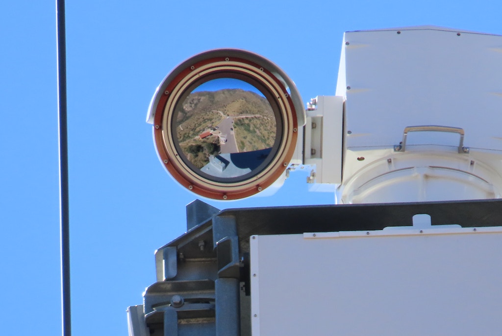
A close-up shot of a Federal Telecommunications Institute camera lens, reflecting the desert landscape that it looks over below Coronado Peak in Hereford, Ariz.
Electronic Frontier Foundation
Surveillance towers have been significant part of that vicious cycle, even though, as Maass’s EFF report notes, their efficacy is far less certain than their considerable price tag.
Nobody can say for certain how many people have died attempting to cross the U.S.-Mexico border in the recent age of militarization and surveillance. Researchers estimate that the minimum is at least 10,000 dead in the past two and a half decades, and most agree that the true death toll is considerably higher.
Sam Chambers, a researcher at the University of Arizona, studies the relationship between surveillance infrastructure and migrant deaths in the Sonoran Desert and has found the two inextricable from one another. While the purpose of surveillance towers in theory is to collect and relay data, Chambers argues that the actual function of towers in the borderlands is more basic than that. Like the agents deployed to the Rio Grande in Operation Blockade or a scarecrow in a field, the towers function as barriers pushing migrants into remote areas. “It’s made in a way to make certain places watched and others not watched,” Chambers told The Intercept. “It’s basically manipulating behavior.”
“People cross in more remote areas away from the surveillance to remain undetected,” he said. “What it ends up doing is making the journeys longer and more difficult. So instead of crossing near a community, somebody is going to go through a mountain range or remote area of desert, somewhere far from safety. And it’s going to take them more energy, more time, much more exposure in the elements, and higher likelihood of things like hyperthermia.”
“There’s nothing to suggest anybody’s trying to make this humane in any manner.”
Last year was the deadliest on record for migrants crossing the southern border. While the planet is already experiencing a level of human migration unlike anything in living memory, experts expect human movement across the globe to increase even further as the climate catastrophe intensifies. In the U.S., where the nation’s two leading political parties have offered no indication of a will to abandon their use of deadly landscapes as force multipliers on the border, the multidecade wave of dying shows no sign of stopping anytime soon.
“They’ve been doing this, prevention through deterrence, since the ’90s,” Chambers said. “There’s nothing to suggest anybody’s trying to make this humane in any manner.”
This content originally appeared on The Intercept and was authored by Sam Biddle.
Sam Biddle | Radio Free (2023-03-20T17:00:40+00:00) Mapping Project Reveals Locations of U.S. Border Surveillance Towers. Retrieved from https://www.radiofree.org/2023/03/20/mapping-project-reveals-locations-of-u-s-border-surveillance-towers/
Please log in to upload a file.
There are no updates yet.
Click the Upload button above to add an update.